Yesterday’s trip up the Colorado River was so interesting, we decided to explore the Lower Colorado Scenic Byway today. This was a totally different adventure. The road is only 17 miles long before it turns to dirt and continues into Canyonlands National Park. We drove the road as far as it was paved (again, not having the appropriate car to explore off-road). This portion of the scenic byway follows the Colorado closely, with the river on one side of the road and steep reddish-orange sandstone cliffs on the other. After turning off Hwy 191, it isn’t long before we were in the deep gorge of the Colorado River. About 4 miles along the byway, we came upon lots of rock climbers in an area they call Wall Street. It looked like many were just learning the sport because they weren’t climbing very far up the cliffs.
A little further down the road we looked for
a site we’d read about that had petroglyph panels along the cliffs. It wasn’t too hard to find because the
numerous cars gave the location away.
Once you found the elevation of the inscriptions, they were pretty easy
to spot.


It was hard taking photographs because the petroglyphs were on a rock that was a black color. It was hard to see the detail through the lens at that distance, but when I got home and put them on my computer, I really got some good shots.

Further down the road was a turnout and description of dinosaur
tracks. The rock with the tracks was halfway up a not-very-defined trail
of boulders. Dave hiked (crawled) up and took a photo (I learned my
lesson and decided this climb was way too difficult for me).
Unfortunately, the photo had something funky going on with it and I couldn't dowload it to the blog.
Unfortunately, the photo had something funky going on with it and I couldn't dowload it to the blog.

Dave
was itching to get a golf club in his hands, so in the afternoon, he went to
the local golf course for some putting and chipping practice. Because tomorrow’s our departure from Moab,
we decided to go out to dinner for our last evening. There was a huge Jeep Rally in town and most
of the people who arrived in our RV park in the last few days were towing a
Jeep.

They signed up for off-road trips
of differing difficulties and they all went out in caravans into the desert
(some were climbing slickrock trails over boulders..yikes!). Anyway, the restaurant we went to was Zax right on Main Street. We sat outside and
watched all variety of Jeep and other off-road, street legal, vehicles parade
by. It was pretty entertaining.


Home
to do clean up and packing for our early departure tomorrow.
Day
76, Monday March 21
Moving
day again. Today we headed north to what
we thought would be northern Utah for our nightly stop. After we mapped it, we decided we could make
it farther north than that, so ended up in Declo, Idaho. The day was clear and sunny. We hated to leave the nice weather in Moab,
knowing we’d be heading into colder weather (and wetter) north. We drove north to I-70 and then picked up
US-191 north toward Provo. Because the
weather was warm, we weren’t too worried about snow going over Soldier
Summit.
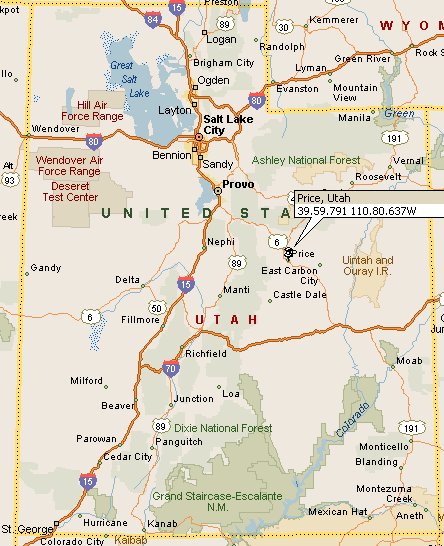
 The scenery on US-191 was pretty
much desert the whole way to Price, with cliffs in the near distance that were
home to some major mining operations. We
saw lots of rail and trucks moving coal from places like East Carbon and
Wellington. We soon discovered that as
the canyon narrowed, we were travelling through the middle of these mining
towns like Price, Spring Glen and Helper.
Outside of Helper, we began our climb over Soldier Summit (elev. 7,477
feet). At 11:30am it was sunny, but
windy. When we reached the summit I
checked the temperature and it was 54 degrees and the road was clear. We did see some patches of snow alongside the
road, but that was all. Smooth
sailing. We picked up I-15 at Spanish
Fork and took the freeway all the way north until Tremonton where we branched
off on I-84 toward the Idaho border. The
drive through northern Utah and southern Idaho was beautiful. Most all of it is farmland and it’s all
starting to green up with spring. Just
before we came to the intersection of I-86, we saw lots of signs that said we
were in high dust storm areas and not to stop on the highway. Fortunately, it wasn’t blowing enough that we
had any threat of dust storms, but we could see how this would be a possibility
with the right conditions. We did pass
multiple gates that could close the highway as needed, so it was obvious the
signs could be a reality.
The scenery on US-191 was pretty
much desert the whole way to Price, with cliffs in the near distance that were
home to some major mining operations. We
saw lots of rail and trucks moving coal from places like East Carbon and
Wellington. We soon discovered that as
the canyon narrowed, we were travelling through the middle of these mining
towns like Price, Spring Glen and Helper.
Outside of Helper, we began our climb over Soldier Summit (elev. 7,477
feet). At 11:30am it was sunny, but
windy. When we reached the summit I
checked the temperature and it was 54 degrees and the road was clear. We did see some patches of snow alongside the
road, but that was all. Smooth
sailing. We picked up I-15 at Spanish
Fork and took the freeway all the way north until Tremonton where we branched
off on I-84 toward the Idaho border. The
drive through northern Utah and southern Idaho was beautiful. Most all of it is farmland and it’s all
starting to green up with spring. Just
before we came to the intersection of I-86, we saw lots of signs that said we
were in high dust storm areas and not to stop on the highway. Fortunately, it wasn’t blowing enough that we
had any threat of dust storms, but we could see how this would be a possibility
with the right conditions. We did pass
multiple gates that could close the highway as needed, so it was obvious the
signs could be a reality.
 The scenery on US-191 was pretty
much desert the whole way to Price, with cliffs in the near distance that were
home to some major mining operations. We
saw lots of rail and trucks moving coal from places like East Carbon and
Wellington. We soon discovered that as
the canyon narrowed, we were travelling through the middle of these mining
towns like Price, Spring Glen and Helper.
Outside of Helper, we began our climb over Soldier Summit (elev. 7,477
feet). At 11:30am it was sunny, but
windy. When we reached the summit I
checked the temperature and it was 54 degrees and the road was clear. We did see some patches of snow alongside the
road, but that was all. Smooth
sailing. We picked up I-15 at Spanish
Fork and took the freeway all the way north until Tremonton where we branched
off on I-84 toward the Idaho border. The
drive through northern Utah and southern Idaho was beautiful. Most all of it is farmland and it’s all
starting to green up with spring. Just
before we came to the intersection of I-86, we saw lots of signs that said we
were in high dust storm areas and not to stop on the highway. Fortunately, it wasn’t blowing enough that we
had any threat of dust storms, but we could see how this would be a possibility
with the right conditions. We did pass
multiple gates that could close the highway as needed, so it was obvious the
signs could be a reality.
The scenery on US-191 was pretty
much desert the whole way to Price, with cliffs in the near distance that were
home to some major mining operations. We
saw lots of rail and trucks moving coal from places like East Carbon and
Wellington. We soon discovered that as
the canyon narrowed, we were travelling through the middle of these mining
towns like Price, Spring Glen and Helper.
Outside of Helper, we began our climb over Soldier Summit (elev. 7,477
feet). At 11:30am it was sunny, but
windy. When we reached the summit I
checked the temperature and it was 54 degrees and the road was clear. We did see some patches of snow alongside the
road, but that was all. Smooth
sailing. We picked up I-15 at Spanish
Fork and took the freeway all the way north until Tremonton where we branched
off on I-84 toward the Idaho border. The
drive through northern Utah and southern Idaho was beautiful. Most all of it is farmland and it’s all
starting to green up with spring. Just
before we came to the intersection of I-86, we saw lots of signs that said we
were in high dust storm areas and not to stop on the highway. Fortunately, it wasn’t blowing enough that we
had any threat of dust storms, but we could see how this would be a possibility
with the right conditions. We did pass
multiple gates that could close the highway as needed, so it was obvious the
signs could be a reality. |
| forgot to take a pic of our site |
Day
77, Tuesday March 22
We
didn’t plan to travel any further than Boise today. It shouldn’t have taken more than 2-3 hours, but
we were heading into a storm cell that was predicting winds at 30mph with gusts
to 40+mph. We left at 10am, and decided
we’d try the interstate and see how difficult it was. If the winds were too bad, we’d resort to the
old side highway where we could travel at a lesser speed. The wind was on our nose (not good for the
gas mileage, but oh well) most of the trip and we kept our speed at about 50mph and
stayed in the slow lane. The truckers
were moving by us at 70mph, but we just kept on driving at our own comfortable
speed. Even Cassey came out for most of
the drive (now that we’re on our way home, she’s getting braver). All the wind was in front of a storm that we
finally caught up with as we approached Boise.
Hail! Not just rain, but
hail. At least it cleaned the windshield
of bugs.

With a quick lunch stop and a
gas stop, we got to the Boise Riverside RV Park at about 3pm. We plan to be here 3 nights.

 |
| Our view out the windshield |


No comments:
Post a Comment